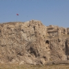
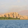
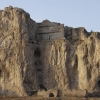
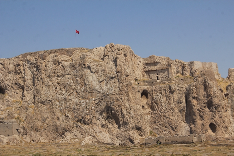
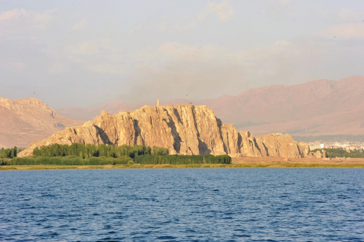
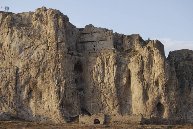
Van Castle is an extraordinary rock elevation in the middle of the plain on the east coast of Van Lake and has an impressive silhouette even from far away. This conglomerate is about 1350 meters long in the direction of the east. Its width is 200 m in places and its height is up to 100 m in some places. The rock mass, which is made by relatively low terraces in the north direction, is perpendicular to the south from a cliff. It rises dramatically from the plain level, like a sharp wall.
The southern part of the Van Fortress was particularly impressive for many travelers visiting the area, with castle depictions, engravings and paintings often portrayed in this respect. The Van Castle constitute one of the important topics of the Van travel for the Armenian historian Movses Khorenatsi (5th century, according to some sources, the 8th century), Evliya Çelebi and the western travelers who visited the castle especially in the 19th century.
A.H Layard visited Van in 1849. In the following years, he managed excavations in Toprakkale and Van Castle by his assistant H. Rassam. In 1916 Russian archaeologists such as Marr and Orbelli, who continued archaeological excavations during the Russian occupation of the region, conducted excavations at the Van Castle. The archaeological excavation of Analı Kız (Daughter with Mother) and the surrounding areas and the archaeological excavations, all revealed the structure. Between 1938 and 1939, Kirsopp Lake and Dr Silva Lake conducted an excavation at the Semitic Museum of Harvard University Brown University at Van Castle.
In the 1960s, the excavation and research work carried out in the Van region under the direction of Prof. Dr. Afif Erzen included the Van Castle. In 1963, a sounding excavation was carried out at Van Castle Mound. Excavations under the direction of Sitadelde Erzen continued between 1972-1975. The more comprehensive studies were conducted by Prof Dr. M. Taner Tarhan and Professor Veli Sevin between 1987-1991. The last period archaeological studies in the castle have been carried out by Istanbul University since 2010 under the chairmanship of Associate Prof. Dr. Erkan Konyar.
The topographic structure of the Van Rock can be divided into three sections taking into account the location and quality of the structures on it. In the middle there is the Upper Sitadel or the Inner Castle, which is also limited by the eastern and western ditches. This is the highest part of the fortress and has always housed important building groups in the historical process. For example, the Old Palace of the Urartian Period and the first groups associated with it are considered to be in this area. In Upper Sitadel, the lower rocky mass extends to the east of the trench-bound area. Evliya Çelebi defined this area as Kesik Kale (Truncated Castle). The term truncated must be defined for the trench. According to many researchers, the part between the two ditches was used in the early and development of Urartu. Sitadel has moved out of the ditch in the course of progress. Urartian structures such as Analı Kız (Daughter With Mother), East Rooms, Cremation Tomb are in this direction.
The western part of the rock extends from the west ditch to the west. This section descends to the level of the plain. Many sources report that this is the way to the castle. Indeed, the natural structure of the rock provides easier access to the fortress only in this direction. The fact that there are architectural arrangements for defense towers and systems in this area also supports this. Many building groups related to the Urartian period are also located on this mass. In its highest part, the New Palace sits on large terraces created by flattening the main rock. The Horhor Tombs, which took the name from the water resources in the south of the rock again, the Minua Barn in the north and the Madır Burç on the plain level are among the important building groups. The Horhor region and the western end of the rock are rich in water resources. This qualification still continues today.
The citadels surrounding the citadel carry the traces of the time period from the Urartian period to the 19th century. Today, the surviving survivor system rises on the walls of Urartu at many points. It is possible to distinguish the traces of different periods from the walls of the castle. On the basement foundations carved into the bedrock, the large travertine and limestone and sandstone blocks are the remnants of the Urartian Period wall. In most areas these walls are elevated with smaller block stones, mortar and late period walls rise. In the restoration works carried out in recent years, the walls of the Urartian stone walls, which are unfortunately built without mortar, are filled with mortar and the original texture has been destroyed. The foundations also allow us to determine the location and route of the Urartian period walls. It is good to repeat a detail here. Especially in the Urartu Period, some of the buildings were constructed on terraces that were parallel to the topography, and the buildings on the terrace walls became part of the defense system. Especially in areas such as New Palace and Analı Kız (Daughter with Mother), the foundations starting on the rocks just above the level of plain are the product of this characteristic approach of Urartian architecture. In this way, the rocky, stepped natural terraces in the north were made suitable for the construction with artificial terraces that were placed on the ground beds and at the same time the high walls served as walls. The south direction of the fortress is quite steep as previously mentioned. In the southern part of the New Palace Upper Sitadel area, which is probably fortified for the basic systems where the structures will sit, the arrangement of any fortification system on the southern side of the rock is not noticeable.
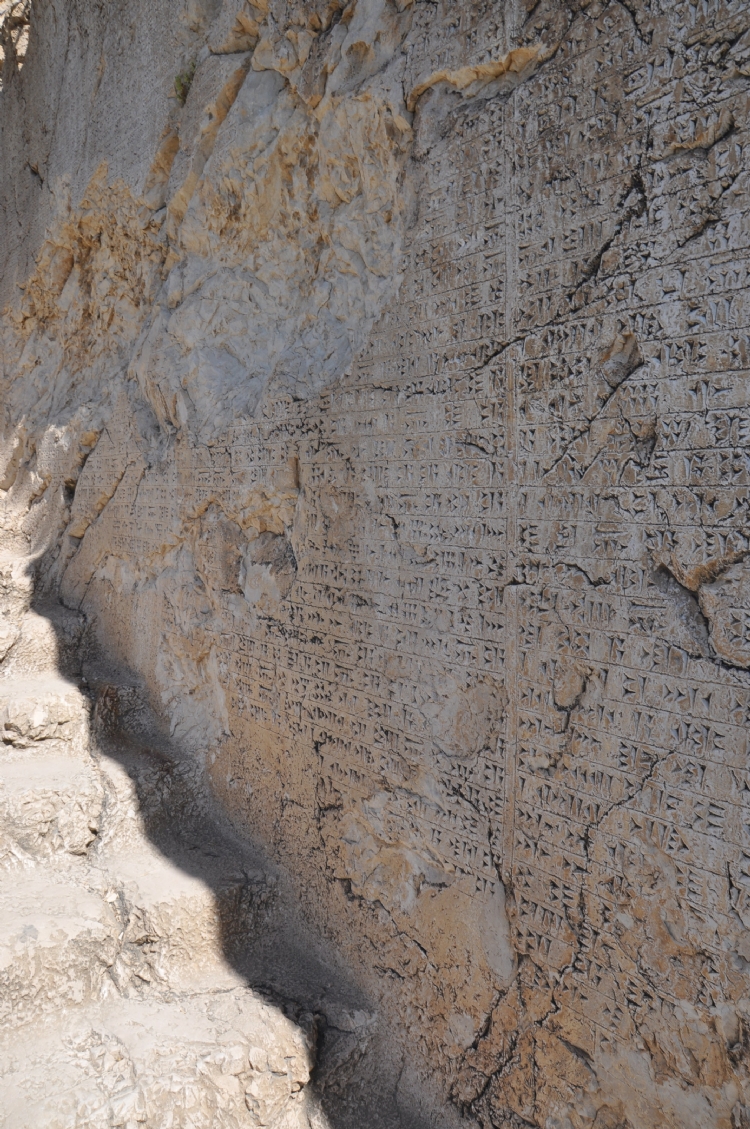
Sardur Bastion (Madır Bastion): When the reference of the Sardur Bastion or the other name Madır Bastion inscription on the west end of the Van rock is taken as a reference in the north-south direction. This section is the oldest known king structure of the city. The Sardur Bastion, which measures 47x13 m and reaches an average of 4 m in height, extends in approximately northwest-southeast direction. Some opinions have been put forward about the function of the building constructed in the overlay technique from the rather large travertine blocks, some of which are estimated to have a weight of approximately 8-10 tons in 5 rows. The founder of the Urartian Kingdom, I. Sarduri, writes in Assyrian language and inscription in the inscriptions replicating each other face in the east and west:
“Inscription (tablet),The son of Lutibri, Sarduri, the great king, the king of power, the king of all things, the king of land of the Land of Nairi, the unique king, marvelous shepherd, never afraid of war, subdues the rebels, (I) Lutibri's son Sarduri, king of kings, I took tribute from all the kings. His son Sarduri of Lutibri says: I brought the limestone of this building from the city of Alniunu. I built this wall.”
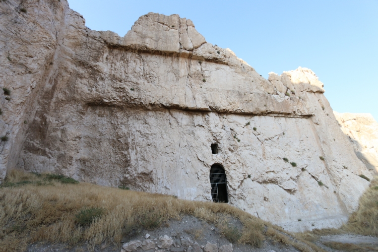
Tabriz Door Rock Alcove And Inscription: Rock alcove was opened to the rock surface under the Tophane Tower at the eastern end of the Van rock. The inscription is in a rectangular frame with a diameter of 3.10x1.45 meters and a depth of about 5-10 cm. There are 34 lines of cuneiform script in the frame. It is very important in terms of content at two points. It is dated to the İşpuini-Minua period, which is called the common kingdom.
Royal Rock Tombs: The rock tombs in Tushba are the most important sources for determining the characteristics and chronologies of the Urartian rock tombs. For this reason, in the context of the above general evaluations, graves in the Van Fortress were evaluated under a separate heading in order to establish the aforementioned definitions and relations in a sound manner.
There are a total of 8 rock tombs on the south side of the Tuskan-Van Rock. The opening of the façades of the grave rooms to the south is related to the structural character of the rock. In this area, Van Rocks are quite steep, especially with less craftsmanship, it is easier to produce monumental, smooth facades. For example, in order to open a monumental façade on the northern outcrops, more labor and excavation were undoubtedly needed. The southern face of the rock gives some ”conscious" corrected natural surfaces to some Urartian architects. The rock-cut tombs built in hard-to-reach areas would undoubtedly make it easier to secure the grave gifts and the grave.
The inner castle grave and the neft well grave in the vicinity of the Great Platform, the East Chambers to the east of the Ditch and the I. Argişti Grave located at the west of the West Trench are parallel with some of their structural features and dimensions. The "Cremation Grave" which is planned as the only room / hall on the east side of the Van Rock, is a unique example in many respects and differs with other graves. The small Horhor Grave, the Arsenal Grave, and the Grave at the Great Platform each reflect a unique plan. The grave of the BG90, which was discovered in recent years, shows a different tradition with its plan and structural features. This example is very important in terms of being the application of the burial chamber with dromos carved into the bedrock under the ground.
As we mentioned before, the general view is that the Urartian kings were buried in the Van Fortress. The main basis of this proposition is the absence of any rock tombs in the main Urartian king centers such as Karmir-Blur (Armenia), Arinberd (Armenia), Çavuştepe, Ayanis, Anzaf and Toprakkale.
The multi-chambered rock tombs of Urartu were probably used as a dead house. The main hall, the arrangement of the side rooms that open to the main hall, the facade of the East Rooms and the neft Well Grave show that they reflect a house and even a palace architecture. These structures, which usually have an organic bond with the sitadel part and are built inside the fortification, have rock platforms descended by stairs. The large main halls, which are reached by the single winged door, and the grave chambers reached to these halls by the door opening again point to very complex structures from the simple burial areas processed to the bedrock. It is very difficult to comment because there is not an in situ finding of how the internal arrangements of these graves might be. However, some details in architecture make it possible for us to make limited comments.
It is suggested that Assyrian practices may have been taken as reference to the construction of the Urartian king graves in sitadel, in a position accessible by stairs. The carving of the ceiling of the main room in the neft well and inner castle graves in the form of a barrel vault was also evaluated. Because the top cover of the graves built under the ground in the citadels of the Assyrian and Nimrud capitals was formed with a brick in the form of a barrel vault.
Rock tombs in the East Rooms, Neft Well, the inner wall of the tombs between the side wall and the upper cover, carved into the rock with half-round protrusions and erasures of cornice is a remarkable detail that gives clues about the architectural origins of the tombs. Sometimes it is tried to express the top cover construction with cornices made by carving the main rock to the point where the side walls intersect with the top cover in two rows sometimes. In the Urartian architecture, there is no doubt that the top cover of the structures was formed by the timber / lumber arranged side by side. With these molds in these tombs, the building structure was most likely to be represented. This arrangement is seen in the inner hall grave and in the main hall of the East Rooms. The main hall and grave chamber 2 in the Neft Well Grave have a different understanding of the cornice formed by two-row half-round series. The cornices in the neft well burial chamber have similarities with the applications in Mazgirt-Kaleköy rock tomb, which is the second Russian inscription on the entrance. At this point, it should be discussed that there may be a chronological connection between neft Well Tomb and the second Rusa period.
Alcove application is seen in Urartu geography in tombs in graves, in rural areas and in underground carved tombs. The very small alcove is lined along the Van fortress Argişti grave and the Tutak / Atabindi grave. In Palu 3 numbered grave alcoves of the same size are striking. There are also alcoves in the rock grave in Iran / Sangar. In addition, alcove applications are common in Altıntepe and Kalecik underground carvings in the northeast of the Van Fortress.
The chronologies of the burial chambers are highly controversial. There are no tombs on which the annals of the Argişti I are written and therefore no dating or evaluations can be made on the basis of style critique or advanced architectural workmanship, except for the Great Horhor Tomb. However, the style critique and the dating made from the architectural developments and positions of the graves bring some discussions. For example, why there is no inscription of the Sarduri II, the son of Argassi I who adopted the same tradition as his father in the Eastern Grave, which was mostly related to the second Sarduri, in the Eastern Tomb dated to the second Sarduri. Why is there no inscription in the possible burial chamber of the Rusa II, who has long written inscriptions in the kingdoms of the city where perhaps the most intensive use of writing and the significant developments in the architecture and many other points of the Urartu? When the tombs were dated to the first Sarduri, Ispini or Minua because they were located in the ditch and under the upper sitadel, it was dated because of the location of the Tomb of the Founders apart from the ditch, dated to the Sarduri I by the inscription on it, and even outside the wall, does the date of the Sardur Bastion structure in the plain base be questioned? Because the early structures in Van citadel should be located among the trenches, and the expansion of the structures with the expansion of the citadel is considered an important criterion in the dating of the structures in the site. It is possible to increase the number of these contradictions in the dating of the burial chambers. Unfortunately, the archaeological and philological data obtained so far makes it difficult to assume which tomb can belong to which king. In fact, the chronology of the Great Horhor cave, where only the political activities of Argişti I, can be considered, in the same context. Due to the inscription at the entrance of Van Fortress, Minua, which is a large hall carved into the main rock which is dated to the Minua Period, carries parallels with the graves in terms of its construction technique and understanding. When discussing the chronology of burial chambers, this argument should not be ignored. At least from this structure it is understood that Minua was the first king to structurally intervene in the Tushba Rock.
Upper Citadel and the Old Palace: ‘The Citadel’ is surrounded with a wall reaching a height of 10 m. The walls which were constructed in Urartu Era were used until the beginning of the 20. century with some repairment and additions. The walls which were constructed by corbelling technique using huge travertine blocks are dated to the foundation period of the Kingdom and to the Menua Era in some studies considering their construction materials, building technique and location features.
The citadel surrounded with the walls is reached through a gate from west side. This place is the highest part of the Van rocky fields and the Citadel and also the endpoint of the sloped way. The area which lies after the gate is in the form of a large platform today. The intensive usage of this area where the artillery barracks and the houses are situated in the beginning of the 20. century, in the historical process led to the formation of a very thick filling on the Urartu structures.
This citadel shows similarity to Sardur Tower structure which is located in the west endpoint of the citadel especially in terms of construction material and masonry. Thus, it is called as ‘Old Palace’ by being considered as one of the early constructed structures of the Kingdom which was cınstructed in its foundation period with regards to its location and the quality of its masonry.
It is considered that the construction foundations which was engraved to the main rock and which was uncovered in the excavations between 1988-1991 in the very southeast of the old place structures can be the temple. This unique structure which doesn't have any example in the Urartu architecture has double cella (temple room). It is suggested that this could be a high tower type Urartu temple by deducing from its wall foundations which was engraved to the main rock having a thickness of approximately 2 metres.
The New Castle: The New Castle area includes the area between the west ditch of Van Castle/Tushba Citadel and Argisthi I Tomb. In nearly all of this area, the main rock was smoothed in order to form smooth areas and terraces where the structures can be built. Wall bases lying for metres are built in form of steps by engraving and shaping the main rock to place the terrace walls.
Today only foundation bases carved into the main rock, walls of the place, smoothed platforms and structure bases remain.Since it lies to east right above the tomb of Urartuian King Argisthi I, it is thought that it was constructed by this king. There is no archeological data to help dating it except its location.
Some results showed up regarding the quality of structures in the New Palace area and its architectural foundation understanding. The first point we must specify is that the data about the naming of the mentioned area as New Palace is quite insufficient. Because the evidences which can be traced on the surface except the attention given in the foundation of this area and its size do not point out to this speciality of the area. Only in the 1980s in the excavations which was carried out under the presidency of Prof. Dr. M. Taner Tarhan in this field, the places in the ground floors of the structure having terraced sides which were probably used as storerooms or service units were reported. The walls of the most of these 12 storerooms and service units were also built by engraving the main rock. And above these, the upper levels are placed on the foundation bases which were again formed by carving the main rock. On the very west part, the vastest part of the New Palace which was formed by smoothing the main rock lies. It is stated that probably the royal mansions and units are located on the second or upper terraces which are carried by these walls.
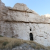
Analıkız Sanctuary: The rock platform having a size of 51 x 13.50 metres which is located in the northeast side of Van Castle is known as “Analı Kız(Daughter with mother)” or “Hazine Kapısı (Treasury Gate)” together with the two monumnetal niches in its southern part. The niches are opened to the southern side which was organised as two levels by smoothing the main rock. The western niche is opened to a surface which was formed in a second level. It has a height of 8.10 m., a width of 2.60 m. and a depth of 2.56 m. nd the eastern niche which is opened to the surface formed in the front level and which is at the left side of the other one has a height of 6.15 m., a width of 2.60 m. and a depth of 2.15 m. A terrace which lies throughout the area where the surface which the niches open to it and the platform joints was also formed by carving the main rock.
Inside the big Western Nice, there is one of the longest cuneiform scripts of Urartu which was written on the main rock and blocks. The scripture which consists of 13 lines at the front side and 29 lines at the eastern side was engraved to the main rock. Some kind of an inventory related to the military and economical potential of the kingdom is listed in this scriptures which are considered to form the beginning of the chronicals of the Sarduri II. Today the pedestal which the stelas inside the niche is based is situated in the area as three parts. The square basaltic pedestal which has a size of 1,56x1,54 is at the height of 1,09 meter. And in the middle of the pedestal there is a stela hole which has a size of 56x45 cm and a depth of 60 cm. And scriptures in which the campaigns and activities of Sarduri II is described is also located in the front side of this basaltic pedestal. And some of the cuneiform scripted stelas and stone blocks which also belongs to Sarduri II and which were taken from this area and used as construction material for the churches in the old city of Van are exhibited in Van Museum.
These niches in which the scriptures dated to the era of Urartian King Sarduri II (755-730 BC) is situated and the platform in front of them are considered to be the part of an open air temple where religious ceremonies are performed in the Urartian period. However, some evidences showing that the area can actually be an enclosed place/structure are also asserted.
Shirsinhi of Menua: This scripture which was carved into the main rock on the right side of the entrance of a one-roomed and low structure which is defined as Menua Shirsini (Şirşini) inside the Van Castle is situated. The content of the mentioned scripture is considered as the most important source in order to determine the quality of this structure and it is claimed that this structure can be a royal stable.
Menua Fountain: The definition of Menua Fountain comes from the content of three scriptures which are inside a natural hollow which was formed in the Van Rocky Field, in the north foot slopes of Van Castle
There are cuneiform scripts which repeat each other inside the three niches carved into the main rock. The niches on the upper level have a size of 175x160 cm and a depth of 15-25 cm. And another niche at the lowest level, very close to ground level has a size of 198 x 172 cm anda depth of 40-50 cm. It is understood that the placing of the scriptures on the main rock doesn't form a definite pattern.
Rock Niches: The most widespread opininon related to the functions of T shaped, square and rectangular niches which were formed by carving into the main rock on the foot slopes of Van Rocky Field is that they have a religious meaning. According to the surface scannings 18 T shaped and 7 square or quadrangle niches which are intensified in the varous locations around the citadel are determined. The niches are seen as they were T shaped and at the same level from a distance, but after detailed examinations it is concluded that they were carved at various depths or levels. These features of them arise the idea that they serve a function rather than having only symbolic meanings. The chronology of the niches are aquestion of debate. Yet, these type of niches were found in the castles and settlements dating to the later periods from Urartu in some studies conducted in recent years.
Kurban (Sacrifice) Niche: An U shaped niche which was carved into the main rock is situated at nearly 25 m. east of the east ditch and 35 m. north of BG90 tomb in Van Citadel. The subject of the 20 lines scripture in the northern side of the niche is sacrificial animals and sacrifice rituel. So it is also called as "sacrifice niche". It is understood that the names of King and God do not take place in this scripture which is illiterable due to being so much devastated. It is dated to Sarduri I considering its writing style and being in Assyrian language. The back wall of the niche opening to east which was comprised of the main rock at the west is at the width of 1.65 m. and at the height of 1.50 m. Among the short sides, the one at the north is at the lenght of 1.30 m. A quadrangle stela hole was made at the size of 57x38 cm and at the depth of 45 cm to the floor of the niche. There is a platform in front of the niche at east-west direction and at a 50 cm lower level. The presence of worship areas having a stela in Urartu is known from the stela holes in front of the monumental rock niches such as Yeşilalıç, Meherkapı and from Erzincan Altıntepe Open Air Temple. And on some Urartian seals, stelas which offering ceremonies are conducted in its face are portrayed with tree of life. So it is understood that Van Castle example is an area where sacrifice rituals are conducted considering the content of the cuneiform script and stela hole.